|
|
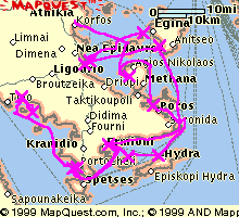
Click on this map of our 1999 cruise around the Greek Peloponnese islands, near Athens, for a larger image and more information about how it was created. (Maps courtesy of MapQuest's "MapFree" service.) Here is a 13Kb MapBlast map of our 2000 cruise around the Croatian islands north of Split, here a 46Kb map of our 2001 BVI flotilla and here a 19Kb map of our 2003 more northerly Croatia flotilla. We went back again in 2005, but this time not so far north and without young Phil. See our track, in Google Earth if wished, and some more photos, here. For a table of all my trips and more Google Earth tracks, see here. |
My Garmin hand-held GPS stores where it is taken as a track; a succession of point co-ordinates.
The tracks were drawn onto the MapQuest bitmap using GPS Utility by Alan
Murphy.
GPS Utility can download tracks directly from a Garmin GPS such as mine but the GPS can only store about two days-worth of track and I was on a two week holiday. I did not have a portable PC to take
with me to do the downloading, but I still had to extract the data somehow while afloat. I downloaded the track information from my GPS to my Psion palm-top every couple of days using a program of my
own. This way I could collect all two week's data.
Then back at home I copied the tracks from the Psion to my PC for plotting with GPS Utility. Of course GPS Utility can do other more serious things directly concerned with navigation. Charts for
these purposes would have registration markings and a known cartographic projection. And GPSU can convert the tracks to Google Earth's "kml" format (see above).
New for 2008, I have a digital camera that (invisibly) embeds the date and time in the data of each photograph I take.
And GPS Utility has a new function that cross-checks the track time against the photo's time (allowing for time zones) and embeds the latitude and longitude in the photo as well.
Then when I upload the photo to my Panoramio page it will be correctly positioned on the map.
My own Psion program, "GarmEdit", can assist with setting up waypoints and routes
and I use it for these tasks while on holiday. I have suppressed the display of waypoints and routes from the maps shown here because they would be too cluttered on this scale.